Originally published to facebook.com/NorthPlattePL on March 25, 2022.
Over the next three Fridays, our Facebook Friday posts will look at the development of transportation and the impact on North Platte:
March 25, 2022: The history behind the Lincoln Highway/Highway 30;
April 1, 2022: Highway 30 comes through Lincoln County and North Platte;
April 8, 2022: The development of “auto courts” in North Platte on the Lincoln Highway and one unique automotive family;
April 15, 2022: the history behind Buffalo Bill’s Trading Post (originally located on Rodeo Road/Highway 30), now known as Fort Cody Trading Post.
Let’s start with the history behind the Lincoln Highway. Read on!
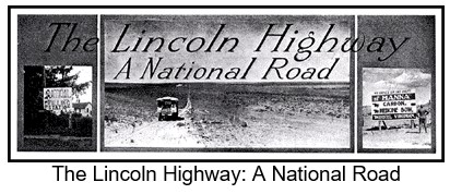
The Lincoln Highway was one of the most famous transcontinental highways, stretching from New York to California. Let’s turn the clock back to before we had the Lincoln Highway and how folks traveled.
In 1912, the definition of a “good” road was one that was graded. Most gravel and brick roads were found in the cities, which means that the open roadways were basically just dirt and sand. Remember, this was before asphalt and concrete roads, so an “improved” road was gravel or brick. In North Platte, the majority of the roads in town were dirt on top of sand, and the country roads were all sand; with North Platte’s downtown being brick streets. America boasted some 2.5 million miles of roads, however most of these dirt/sand roads didn’t connect. These roads were bumpy; dusty in dry weather and impassible mud pits during the rainy or snowy seasons. Travel by train was much easier for the traveling public when going from one town to another.
Now, the thought of developing a connected road system, especially between the coasts had been discussed since about 1902, mainly by Automotive manufacturers.
The American Automobile Association was trying to find support for a road that would connect coast to coast, but finding financing and a labor force to do the work were some serious obstacles to overcome. And the idea was pretty much talked about and considered, but nothing happened.
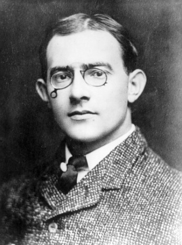
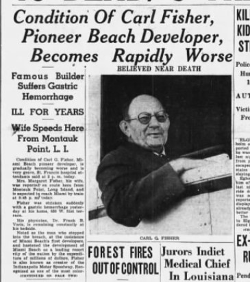
Then, in 1912, Carl Fisher emerges with a plan to build a highway called the Coast-to-Coast Rock Highway. And Mr. Fisher was a man who would turn his dreams into reality. So who is Carl Fisher?
Carl Graham Fisher (1874-1939) was born on January 12, 1874 to Albert and Ida (Graham) Fisher in Greensburg Indiana. Carl was considered an American entrepreneur. He was actively involved in automobile racing and a tireless supporter and promoter of the automotive industry.
He called his idea the “Coast-to-Coast Rock Highway.” The cost would be about ten million dollars, low, even for 1912. Communities along the route would provide the equipment and in return, would receive free materials and a place along America’s first transcontinental highway. The highway would be finished in time for the 1915 Panama-Pacific Exposition and would run from the exposition’s host San Francisco, to New York City.
To fund this scheme, Fisher asked for cash donations from automotive manufacturers and accessory companies of one percent of their revenues. The public could become members of the highway organization for five dollars.
Fisher knew that the success of the ten-million-dollar fund would depend on the support of Henry Ford. Unfortunately, even after many persuasive attempts by friends and close associates, Ford would not support the project. The public would never learn to fund good roads if private industry did it for them, Ford reasoned.
This put the fund in jeopardy; and there would not be enough time or money to finish the highway by the exposition in 1915. Fisher would not give up, especially since the country had become so enthusiastic about the highway. Two men from the automobile industry who pledged money to Fisher’s idea would later play major roles in the highway’s development: of Frank Seiberling, president of Goodyear; and Henry Joy, president of the Packard Motor Car Company
In fact, it was Henry Joy that came up with the idea of naming the highway after Abraham Lincoln. He wrote Fisher urging him to write a letter of protest to Congress which was considering spending 1.7 million on a marble memorial to Lincoln. Joy thought that a good road across the country would be a better tribute to the president. The name “Lincoln” captured Fisher’s fancy; and, he realized it would give great patriotic appeal to the highway. Fisher asked Joy if he wanted to be involved directly with the highway project. At first Joy was hesitant, but he soon wholeheartedly supported the project and became the primary spokesman for the highway.
On July 1, 1913, the association decided to call the coast-to-coast highway the Lincoln Highway, and it was officially incorporated as the Lincoln Highway Association. Henry Joy was elected as president. Carl Fisher, who was elected vice-president, was not present. He had departed with the Indiana Automobile Manufacturers association on a trip to the West Coast. The “Hoosier Tour” was intended, in part, to explore possible routes for the Lincoln Highway. The tour route included Colorado and Kansas. While Fisher tried to distinguish the Hoosier Tour route from the eventual route of the Lincoln Highway, he all but promised the governors of Colorado and Kansas that the highway would pass through their states. They were set up for a big disappointment.
Fisher kept the route of the Lincoln Highway a secret as long as he could because:
1) he wanted the nation as a whole to support the highway, not just the states through which it would pass, and;
2) he didn’t know what the final route would be. No decision had been made. After Hoosier Tour, the association decided they needed to pick a route.
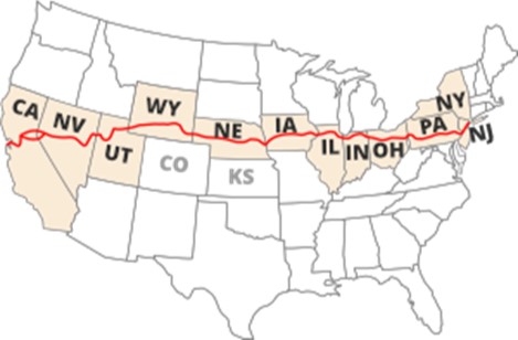
As far as Joy was concerned, directness was the most important factor. By bypassing many scenic attractions and larger cities along the way, narrow winding roadways and congestion could be avoided. After weeks of deliberation, Henry Joy presented the route before the annual Conference of Governors in Colorado Springs. The highway started in Times Square in New York City. It passed through New Jersey, Pennsylvania, Ohio, Indiana, Illinois, Iowa, Nebraska, Wyoming, Utah, Nevada, and California, ending in Lincoln Park in San Francisco. The route did not deviate from a straight path in order to go through larger cities or national parks. It did not touch Kansas or Colorado. Joy’s influence for a direct route was clear.
The governors of Colorado and Kansas were embarrassed for having heartily supported the Hoosier Tour, only to find themselves bypassed. After forceful appeals from Colorado’s governor, the association agreed to a dogleg from Big Springs, Nebraska southwest to Denver, and then back to the main highway at Cheyenne. After the route was announced to the public one month later, the decision to include the dogleg would come back to haunt them.
Almost immediately, the Lincoln Highway Association received letters trying to change the route; it politely declined every request. The association learned its lesson. Two years later, it dropped the Denver dogleg from its maps and guides and warned drivers not to be misled by signs in Big Springs pointing them to Denver.
The Lincoln Highway Association set up a system of people along the highway that acted as local ambassadors. They would represent the highway in local affairs, assist visitors, and let the headquarters know of matters concerning the highway.
By 1914, there wasn’t much of a highway to be concerned about. No improvements had been made to the original Lincoln Highway, and with Ford’s refusal to chip in and growing disinterest of people left off the route, the ten-million-dollar fund that Fisher had set up had stalled at the halfway point. Joy decided to abandon the fund and instead redirect the association to a new goal: educating the country for the need for good roads made of concrete, with an improved Lincoln Highway as an example.
It would oversee the construction of concrete “seedling miles” way out in the countryside to emphasize the superiority of concrete over unimproved dirt. As people would learn about concrete, they would press the government to construct good roads throughout their state.
In March 1925, the American Association of State Highway Officials (AASHO) started planning a federal highway system. Major east-west routes would be numbered in multiples of ten, from U.S. 10 across the north to U.S. 90 across the south. The major north-south routes would end in 1 or 5, from U.S. 1 between Maine and Florida to U.S. 101 between Washington and California.
The Lincoln Highway was then broken up into U.S. 1, U.S. 30, U.S. 530, U.S. 40 and U.S. 50. The Lincoln Highway Association was created in 1913 to promote the Lincoln Highway using private and corporate donations. Americans’ enthusiasm for good roads led to the involvement of the federal government in building roads and the creation of numbered U.S. routes in the 1920s. The Federal Highway Administration and the Interstate Highway System are the culmination of these efforts.
Carl G. Fisher became a very wealthy man in 1913, when he sold his patent for acetylene headlights to Union Carbide for 9 million dollars (equivalent to $240 million dollars in 2021). Carl Fisher married Jane Watts and they had two children together: Benjamin Walker Fisher (1891-1908) and Carl Graham Fisher Jr (1921-1921). In 1927, he married Margaret Eleanor Collier in Virginia. Fisher was not a devoted family man and dedicated his life to his entrepreneurial interests. Fisher eventually lost his fortune in the 1929 Stock Market Crash. He ended up living in a small cottage in Miami Beach doing minor odd jobs for old friends. Although he lost his fortune, Fisher is widely regarded as a very successful man, when viewing his entire life. He had many accomplishments that impacted the history of America. Fisher died on July 15, 1939 from a gastric hemorrhage in Miami Beach, Florida at age 65.
Next week we will look at the Lincoln Highway being constructed and coming through North Platte—both the original and the second generation/ improved highway. Thank you for reading!
And if you want to read more about the Lincoln Highway, stop by the Library and check out some wonderful books on the subject!
#NPHistoryArchives