


The Missouri River & Siouxland - Part 2
How do we change our ecosystems? In our previous article, we discussed how the Missouri River ecosystem came to be, what this ecosystem looked like, and a few different ways different cultural groups saw this river back in the day. But now it is time to discuss how Americans started to change it.
Let’s start with where we left off. By 1803, European colonists had long since arrived in the Americas and started to build themselves up, having set up over about two hundred years. They were still fighting over scraps of land and what power they could find. Part of that was starting to look for unclaimed or loosely claimed land. The world was being divided up by imperial powers hellbent on segmenting and owning everything their leaders could dream of. The United Kingdom lost quite a large stake in the western world due to the United States gaining independence in 1776.
Meanwhile, Spain and France still claimed ownership over massive tracts of the American continents. France specifically is key to our story. At this point, they claimed ownership over much of the western interior in a massive swathe of land they called the Louisiana Territory. The claimed ownership of this area had traded hands several times between Spain and France, but by 1803, it was France who was claiming to own it.
Around this time, the French Republic was having some trouble. Uprisings and revolutions across the Americas were costing them much of their empire, and they already had a tenebrous grasp on the Louisiana Territory at best, only ‘owning it’ by name. At the same time, Napoleon had been biting off more than he could chew and there was war brewing in the east at the French Homeland. Because of these pressures, Napoleon had felt a need to both dust his hands off of another potentially messy situation to the west and raise funds for the homefront in case war did break out.
Thus, enter stage left Thomas Jefferson, the sitting president of the United States in 1803. One of Thomas Jefferson’s long-term goals, even before his term as a US President, was the acquisition of the Louisiana Territory and, especially, the Mississippi River. Around this time, James Monroe and Robert R. Livingston, both on orders from Thomas Jefferson, sought the purchase of New Orleans and the Louisiana Territory from the French Treasury Minister, François Barbé-Marbois. Jefferson and James Madison quickly raised the funds, and thus, the US was now the claimed owners of the Louisiana Territory.
By January of 1804, the US had doubled in size, and by May of 1804, Lewis and Clark had started off on their famous expedition. Lewis and Clark give us some of the best understandings (we have) of the Missouri river from before our changes and also help us understand the context for what changes we Americans will make to the river. They are also among the first Europeans who saw and documented the river, as was mentioned in the previous part. After the expedition ended, people began, over several years, to move west into the interior, which should give us enough context to resume from where we left off in the last part.
The Missouri River – Then to Now
In the early 1800, things remained relatively calm. People began moving into the interior, especially because of the shared American Fur Trade between the US, Canada, and Spain. This is when the forts and early settlements of the western interior began to see their populations grow. The Lewis and Clark Expedition reports and field studies went widely underused and under-reported, in part due, to some seeing it as a failure. The major reason they went west was to try and find a viable east to west waterway, and with hopes that the Missouri River would be exactly that option. In this period, this is before anything close to a major road was established, with the closest to that being the wagon trails. Rivers were the main economic highway, with tugboats, river rafts, and the steamboats being what carried furs, and later cattle and other goods north to south, from St. Louis to Siouxland. Thomas Jefferson and other powerful American figures had hoped the Missouri could be a perfect highway to the west coast, but were sorely disappointed to find it was stopped by the Rockies.
During 1819 and 1820, the United States Congress secured funds for “A survey of the water courses tributary to, and west of The Mississippi” (Acts of 15 February 1819, and 14 April 1820). The money was spend, as evidenced by Congress renewing the funding the following year, but what it was spent on is speculation. The Western US frontier was being discovered and developed around this time, and strong anecdotes of what that looked like are lacking. We know the broad strokes of its development, but not the specific things as there weren’t enough good sources talking about projects relevant to the Missouri River.
On May 24th, 1824, the US passed the Rivers and Harbors act which enabled larger scale river alteration efforts. The first officially established goal by the US Army Corps of Engineers (USACE) was the removal of major snags along the waterway through the efforts of snagboats. (US Army Corps of Engineers – Snagboats, 2009). River snags are tricky because they’ve been shown to be beneficial to the overall health of river ecosystems, slowing the flow, stabilizing banks, and generally providing safe spots of fish and other species to thrive in. However, they are natural barriers that can impact and destroy boats easily and could choke up or completely prevent shipping on the river if not removed. So, to see the transport of goods and people along The Missouri, Congress and the USACE needed the snags gone. Artist Karl Bodmer did many paintings capturing the Missouri in its original look, and his work among many others are our best looks at what The Missouri looked like before we began to change it. See figure 1 below.

Removing these snags caused new problems. Waters started to flow faster, which caused the already unstable banks of The Missouri to start to collapse faster and added sediment loads to the water. The greater sediment load meant more silt and sand was carried downstream, which created more sandbars and islands. This went on to further alter river, causing it to have even greater variation. One of the biggest challenges The Missouri River had was how much it changed and flooded. The banks collapsing and having more variance was exacerbating the already existing problem. Congress saw this and approved further funding for river alterations in 1832 (Ferrell, p. 5, 1995).
These added alterations did help, in the short term. The removal of snags made the river shallower and more unpredictable, but that did not matter for the modes of transport used at the time. By 1850, steamboat navigation had gained popularity for river travel. Steamboats were more efficient, especially for trawling the Missouri River, and thankfully did not need the river to be especially deep, so the only real hazard to them was snags and underwater hazards like trees or other blockages. They were the main source of economic transport for all sorts of small towns and communities, as they were the only stable way to get goods in and out of the American interior. However, this river-based monopoly was about to end.
In 1870, railroads began to spread into the interior of Iowa and the Dakotas (Schneiders, 1996), cutting out steamboats as the economic option for transporting goods. Many smaller communities blossomed because of the steamboats on the river; but as the railroads spread and steamboats dwindled, many small communities declined. In 1881, the last commercial steamboat docked in Sioux City. (Sioux City Journal, 1940)
The main reason for the decline was that Steamboats just could not compete with railroads in terms of cargo volume or efficiency. Around the same time the railroads were being constructed and pushed west, Abe Lincoln signed into effect the 1862 Homestead Act. This encouraged rapid immigration westward, and many individuals would stop at the smaller communities to find them struggling because of the railroad booms and the steamboat collapse.
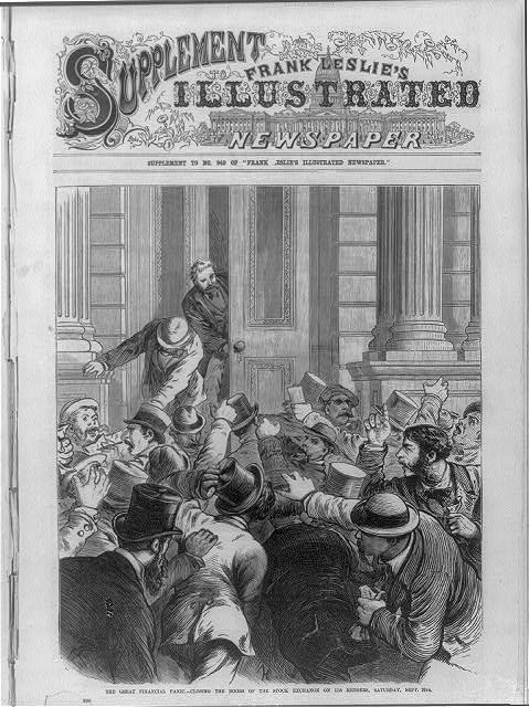
Railroads by this point had also earned a sour reputation in the Midwest in large part because many saw them as monopolies and robber barons. They were taking their economy and putting in a worse option. The railroad industry had grown rapidly, and much of it was speculative investments. 1873 was a perfect example for many, with the September 18th 1873 economic panic caused a notable financial collapse in the United States (PBS, The Panic of 1873), with an economic bubble bursting. See figure 2 for an illustrated rendition of the panic.
This financial collapse, combined with the poor reputation of the railroads and many having already set roots down in these small riverside communities, lead to a revival effort for The Missouri River. Many residents of the Midwest came together to try and re-establish the Missouri River as a form of economic transportation, and would form a private group called the Missouri River Commission. But the glaring issue of how to do this remained. The steamboats failed because they could not carry the volume of cargo needed, so a new option was needed. Thus, a new type of transport was needed, the deep-draft river barge (Schneider, p. 339, 1996), a larger vessel that requires much deeper channels than the previous shallow-draft steamboats. They were, at the time, the only alternative to the railroad. But The Missouri was already shallow, winding, and full of islands and sandbars before the snag removal. After a couple of decades of snag removal and its consequences, the river was much worse. To drive barges up and downstream, The Missouri needed to change more than it already had.
In 1881, the same year that the last steamboat docked in Sioux City, a US Army Corps of Engineer Major, Charges Suter, was developing a plan to cut the many small side bends of the river and funnel the water towards one central channel (Ferrel, p. 9, 1995). By 1882 Congress would make the largest financial commitment to a Missouri River project yet, appropriating 8 million dollars (equivalent to ~ 250 million dollars as of 2026) for actual proper channel development (Goodin, 2018).
Suter’s original plan turned out to be a bit of wishful thinking. His full idea was that by diverting all the water to a central stem of the river, the new flow would have enough current and pressure behind it to scout the riverbed to be deeper and more stable. In principle, this is what happens, but not nearly to the degree that Suter’s plan would have needed to succeed. Instead, what ended up happening is that, from 1882 to 1902, the money from congress went to several villages, towns and cities along The Missouri to help channel the first 44 miles of the river from its mouth to Augusta in St. Charles County, Missouri. This only resulted in a 5.5-foot-deep navigation channel (Goodin, 2018), a far cry from the entire 734-mile stretch from St. Louis to Sioux City.
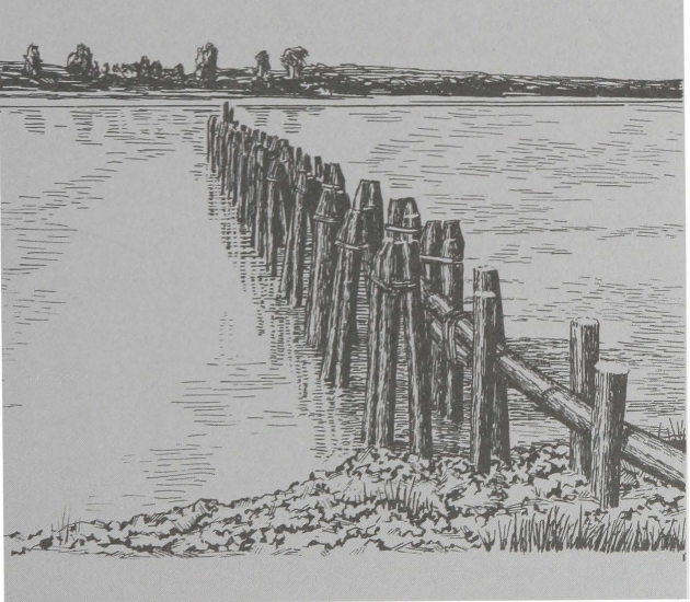
This is not to say Suter’s plan failed. Instead, it became foundational to how future work would be undertaken, and was usually the starting point of any individual section of the river. One of the principle techniques from Suter’s idea was building large silt catching sills out into the river out of wood, rope, and rocks, similar to jetties or groins you’d find around bays. These sills would trap the heavy silt load and gradually stabilize the banks with the original netting to catch the silt now serving as structural support. (Ferrel, pp. 13 – 19). See figure 3 below for an example of these.
Part of why the work started off so slow was because of how the money was set up for use by Congress. In 1881, the Missouri River Commission was embroiled in nonstop special interests which had given them problems, and the funding in 1882 was lower than the Commission needed, despite being the largest to date, because of how the money was distributed. $8 million was appropriated, but it would be released gradually over several years, with only a million dollars being released for use a year. It would also be released to several involved parties, not just the Missouri River Commission. Of the 1 million Congress would approve and release, only about $225,000 would end up being given to the Commission (Ferrel, p. 24, 1995). This is obviously still a substantial amount of money, but not nearly enough to fully fund the work the Commission was trying to do. The other hundreds of thousands of dollars would end up going to smaller villages and towns for local adjustments.
But these first actions were not a failure. They showed that it was possible to channel the Missouri, but it was going to be a substantially harder task than anyone envisioned. Little progress would be made from 1902 to the 1920s, in large part due to bureaucracy. Congress had doubts about whether this project was still worth it, and lobbying by several different states fought over what to do with the river. This was a project that extended across multiple states and affected most of the eastern Midwest, so people had a lot of different opinions that were not made any easier thanks to the wars on going at the time. Upstream changes had already been proven to have negative downstream effects. At this point, millions had already been sunk into the river, and there was barely anything to show for it, so in 1910, Congress held another hearing to discuss whether the river was worth all the effort (Ferrel, p. 35), and in that same year hired a team of 3 engineers to make a new plan. Two years later, in 1912, the engineers finished drafting their responses to congress and dubbed it “The Ten-Year Plan” (Ferrel, p. 41).
Much of the work that would still happen was around Kansas City, with 1.2 million dollars being raised by private commercial enterprises for the purposes of channeling the river (Ferrel, p. 42). But a few short years later after work started, the US would enter World War I and commandeered the new fleet that had been assembled for work on The Missouri. By 1918, work had halted again. By 1921, only 35% of the new “Ten-Year Plan’s” work had been done (Ferrel, p. 51). By 1923, the only work that was still happening was repairing the channel that had been done so far. It wouldn’t be until 1927 that Congress would pass their next major act for the Missouri River. The Missouri River Navigation and Channelization Project would be the first act passed by congress of this scale, focused entirely on this goal. All previous allotments had been part of several other small actions or were handled by other departments, but this was a standing order from the top down.
This new bill ordered that the US Army Corps of Engineers, not the Missouri River Commission, would make the 6-foot-deep navigation channel from Kansas City, Missouri all the way to a growing place on the border of Iowa and Nebraska called Sioux City. The most notable thing about this act was that funding would not be secured by Congress, and instead it would be on each state to apply for the funding from Congress on a yearly basis (Schneider, p. 340, 1996). This was in 1927, which could not have been worse timed. Two years later, in 1929, the Great Depression would start in the US, crippling America’s economy. Less than a full year later, the Dust Bowl would also hit the Midwest in 1930. This were bleak for the Missouri River Navigation and Channelization Project, and it hadn’t even gotten its feet off the ground yet.
Afterword
I know in part one I said this would only be three parts, and originally that was the plan. In fact, that was the plan up until two days before I was due to publish this second part. During the editing of this part, I’d found several gaps in my research which I did not feel right leaving unfilled. So, I ended up doing even more research, which bulked this originally 2000-word section into an almost 4500-word section. I felt that had veered so beyond just a small blog post, but I also didn’t feel right cutting a lot of that information, so I made the frustrating choice to split it down the middle again, making this overall project 4 parts now.
The next part is going to carry us through our survey of the river’s history, up until the river of today. Sadly, this means the third part is now the fourth part, and it is going to be pushed back in its release, but it also means there is more time to keep doing research! What is crazy, and perhaps unsurprising about this whole thing is how robust this history is, and how spread-out information is. Part of what created the big gaps originally was that some sources just completely ignored information that other sources readily provided, and even those sources just missed other things. It was frustrating but not shocking to me that something this large was not as simple as it seemed, even after a dozen or so hours of in-depth research.
Once again, I want to draw your attention to the South Sioux City Public Library and all its amazing sources, especially the Journals of Lewis and Clark. I could never find the chance to slip some of the amazing quotes from there into this work, because we needed to move so fast, but their journals were where I started this project, and what made me realize how much this river had changed. But we can save that for the next part. Once again, thank you and I look forward to seeing you next time!
Work Cited
US Army Corps of Engineers. (2009, September) Snagboats. US Army Corps of Engineers Headquarters Website; https://www.usace.army.mil/About/History/Historical-Vignettes/Civil-Engineering/120-Snagboats/
Missouri Department of Conservation. (n.d.) Bottomland Forests. Missouri Department of Conversation Main Website. https://mdc.mo.gov/discover-nature/habitats/forests-woodlands/bottomland-forests
Schneiders, B. (1996). The Myth of Environmental Management: The Corps, the Missouri River, and the Channelization Project. Agricultural History, 70(2), 337–350. http://www.jstor.org/stable/3744541
Ferrell, J. (1995). Soundings: 100 Years of the Missouri River Navigation Project. https://usace.contentdm.oclc.org/digital/collection/p16021coll4/id/95/
U.S. Army Corps of Engineers, Federal Engineer, 4; Sioux City Journal, 27 June 1940.
PBS, The Panic of 1873, Public Broadcasting Service, PBS, Retrieved March 25, 2026 from https://www.pbs.org/wgbh/americanexperience/features/grant-panic/
(1873) The Great Financial Panic of- Closing the door of the Stock Exchange on its members, Saturday, Sept. 20th. , 1873. [Photograph] Retrieved from the Library of Congress, https://www.loc.gov/item/99614016/.
Goodin, Art; Missouri River – PUB2018 – Water Protection Program Fact Sheet (2018), Missouri Department of Natural Resources.gov, Retrieved February 19, 2026 from https://oembed-dnr.mo.gov/document-search/missouri-river-pub2018/pub2018